Documentation
Help & Knowledge Base (link)
Rapid, Remote and Remote Expert Operating Instructions (pdf)
Imagery Processing and Photogrammetry 101 (link)
Aerial Data Collection Guidelines and Mission Planning (pdf)
Verify Imagery Geotags (pdf)
KAP UAV Canon Camera CHDK Exposure Control Script (link)
DroneMapper CHDK Installation / Canon PowerShot SX260HS (pdf)
DroneMapper CHDK Setting Screenshots (pdf)
Ground Control Point Information (pdf)
Viewing DroneMapper GIS Products (pdf)
Transferring Imagery to DroneMapper (pdf)
DroneMapper GIS Products and Global Mapper Tutorial (2D/3D/Cut/Fill Measurements) (pdf)
DroneMapper FAA 333 Exemptions - Benefits, Limitations and Suggestions (pdf)
Pteryx UAV: Aerial Mapping Secrets (pdf)
Rapid, Remote & Remote Expert Information
Imagery and Data Collection Applications (link)
Example Aerial Oblique / NADIR Imagery Data Collections (link)
Drone Mapping Software EULA, Trial/Evaluation Licenses (link)
Processing Oblique or Oblique + NADIR Imagery in 3D Mode (link)
Using GCP (Ground Control Points) and the GCP Tool (link)
Installation Troubleshooting and Hints (link)
3rd Party Libraries, Tools, Open Source, Licenses and References (link)
DroneMapper Geospatial Accuracy and Ground Control Points (link)
Build a "bare earth" DTM from UAV imagery with DroneMapper, LAStools and Global Mapper (link)
Build an Enhanced and Traditional NDVI with DroneMapper and Global Mapper (link)
Generate Contour Lines from Digital Elevation Model (link)
Cut/Fill/Volume and Pile Volume from Digital Elevation Model (link)
Generate a GCP Report with Elevation RMSE (link)
Clip Orthomosaic or Digital Elevation Model to Area of Interest (AOI) (link)
Export Orthomosaic to KMZ Format (link)
FAQ & Information
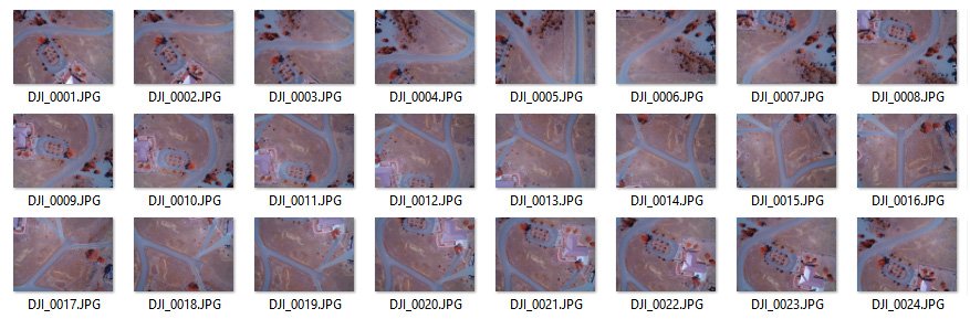
- Imagery must have at least 60% in-track overlap and should have at least 50% cross-track/orthogonal overlap.
- Imagery has overlap between cross-track and in-track image frames.
- Images must contain required EXIF information. (Camera Make, Model, Image Width, Image Height, Focal Length, DateTimeOriginal)
- Shutter Speed >= 1/1000th, Auto ISO, White Balance set to ‘Sunlight’, ‘Day’ or ‘Cloudy’ depending on conditions.
- Images are shot with one camera and focal length.
- Images are geo-tagged.
- Non-NADIR images should be removed if processing a NADIR only collect (Images from Turns, Landing, Takeoff)
- Images should not be pre-processed so EXIF metadata is preserved.
- Images are NADIR or near vertical if processing a NADIR only collect. 6 megapixel or greater, at least 12 megapixel recommended.
- Images are TIF or JPEG format and no corrupt images/headers. Images are same width x height. (4000×3000)
- Images are same aspect ratio. (4:3 recommended)
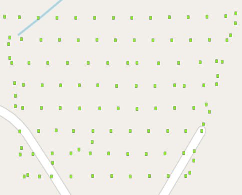
- Flight Path should be Parallel Line (aka Lawn Mower) or other large overlapping style.
- Flight Path should provide sufficient coverage of survey area. Sufficient coverage means 60% – 80% overlap, less than 50% overlap yields less data for gradient generation in that direction.
- Flight should be from sufficient elevation. (i.e. >80 meters) Flights below 50m or less should have identifiable terrain features.
- Use a GPS enabled camera with Latitude, Longitude and Elevation EXIF tags.
- Required EXIF tags include Camera Make, Model, Image Width, Image Height, Focal Length, DateTimeOriginal.
- Geo-tag your photos using GeoSetter (GUI), exiftool (command line) or a similar tool.
- What about the backend? DroneMapper has developed a custom in-house photogrammetry software package for cloud and desktop processing. We do not use Pix4D, AgiSoft, etc.
- How do I get the best results? Check out the DroneMapper Imagery Input Guidelines Page located here.
- How do I pay? You can can with a credit card via paypal, a paypal account or you can request an invoice. Contact us for an invoice.
- You must geo-tag your images or use a GPS enabled camera. Unique GPS EXIF Lat, Lon, Altitude are required for each image. You must have Camera Make, Model, Focal Length and other standard tags in your imagery EXIF metadata.
- We recommend using Ground Control Points (GCP) for the most accurate solution or for precision agriculture applications.
- Imagery and processed products are removed from our servers roughly every two weeks.
- What types of camera sensors are compatible with dronemapper.com? DJI, Canon, Panasonic, SwingletCam, Ricoh, Nikon, UltraCam f80, pretty much anything.
- Where can I get a drone that integrates well with your service? DJI, SenseFly
- Your imagery is protected by IP address and also HTTPS. You can enter multiple IP addresses for which you would like to allow access to your data, this option is available on your profile page.
- Do you offer consulting and/or GIS application development services/partnerships/integrations? Yes, please contact us if you need help with your project or would like to discuss.
- Should I do any pre-processing on my imagery? No, JPGs direct from your camera work best. Certain programs can alter EXIF data or remove it completely. We have support for JPG, TIF, RAW and NEF image formats – please contact us if you require this feature.
- Why did my upload fail? During long uploads if your computer or laptop goes to sleep the upload will be interrupted. In certain cases, sometimes EXIF data isn’t detected properly and the upload can fail.
- GoPRO cameras are not a good choice for photogrammetry applications.
- How do I clip DroneMapper products to a certain Area of Interest (AOI)? Send us a polygon shapefile in UTM or WGS84 projection for the AOI and we will clip your data products to that area before or after processing. Remote and Remote Expert allow the user to clip the results directly from the desktop application.
- We recommend triggering the camera sensor based on distance traveled to obtain consistent overlap and coverage. If you are using a Canon sensor with CHDK installed and shooting using a timed interval – please use the following script: KAP UAV Canon camera CHDK Exposure Control Script. For more information on CHDK and the KAP script: Author Topic: KAP & UAV Exposure Control Intervalometer Script
To enable such generalized use of aerial, satellite and ground-based imagery, geospatial professionals process the collected images with ground coordinates in order to correctly position the imagery in relation to the Earth.
To ensure that the image is in the right position, and that the correct image of the restaurant comes up on the screen of the onboard navigation system in our car, it is necessary to provide accurate ground coordinates to tighten the accuracy of the overhead imagery.
Reliable GCPs are an essential input for precise orthorectification of:
- Remotely sensed imagery
- LiDAR and IFSAR Surface Models
- Image and mapping data quality assessment
- Photogrammetric mapping
and - A fundamental building block of Geographic Information System (GIS) development
DroneMapper requires at least 5 Ground Control Points (GCP) which are visible in at least 5 of your 2D images. To process your imagery with GCP support we require the following data files:
Filename: DroneMapperGCP_3D.txt
NAME X Y ELEVATION PRECISION X/Y PRECISION Z
15196 521414.188 4368210.231 1840.288 0.005 0.007
UAV004 520938.03 4367378.612 1813.835 0.03 0.05
15180 521465.345 4366967.099 1829.826 0.005 0.007
UAV003 521945.249 4366515.498 1861.73 0.03 0.05
15182 522832.461 4367201.373 1890.136 0.005 0.006
15205 522405.402 4366801.531 1857.779 0.005 0.009
Filename: DroneMapperGCP_2D.txt
NAME IMAGE PIXEL X PIXEL Y
UAV004 IMG_0291.JPG 1080 1605
UAV004 IMG_0292.JPG 1130 2851
UAV003 IMG_0306.JPG 1251 218
UAV003 IMG_0307.JPG 1124 1680
UAV003 IMG_0319.JPG 1062 931
UAV003 IMG_0320.JPG 1316 1834
UAV003 IMG_0321.JPG 1189 2674
UAV004 IMG_0347.JPG 1986 236
UAV004 IMG_0348.JPG 1662 1205
UAV004 IMG_0349.JPG 2014 1459
UAV004 IMG_0350.JPG 1968 2147
15205 IMG_0489.JPG 1376 1856
15205 IMG_0490.JPG 1861 2294
15205 IMG_0491.JPG 1176 2645
15196 IMG_1086.JPG 1475 444
15196 IMG_1087.JPG 1510 1035
15196 IMG_1088.JPG 1623 1947
15180 IMG_0299.JPG 452 1592
15180 IMG_0300.JPG 675 2668
15180 IMG_0333.JPG 1651 730
15180 IMG_0334.JPG 1625 1405
15180 IMG_0335.JPG 2463 1936
15182 IMG_1128.JPG 2684 1449
15182 IMG_1129.JPG 3116 2004
15182 IMG_1130.JPG 3310 2579
The GCP txt files should be uploaded with your imagery.