* Please uninstall previous DroneMapper version before updating
Download the latest version here: https://dronemapper.com/software_downloads
Upcoming:
TBD
- Predictive GCP tool
- Additional GPU tie point detectors
Releases:
April 20th, 2022 – v1.9.3 20220420
- Orthomosaic optimizations & disk space fixes
- New GeoTagger function (accepts csv with image names or timestamp for tagging) – BETA
- New MicaSense image stacker (stacks raw micasense images w/ radiometric corrections) – BETA
- UI tweaks & fixes
- UI progress bar and tasks processing fixes
- New Sentera image stacker (stacks raw sentera images w/ radiometric corrections) – COMING NEXT RELEASE!
See the following Medium articles for more information on stacker and geotagging: https://medium.com/@dronemapper
September 20th, 2021 – v1.9.2 20210920
- Bug fix for Point Cloud/PLY generation and very large orthos (>8GB)
- Optimization to DEM processing for large missions or very high resolution GSD
February 10th, 2021 – v1.9.2 20210210
- Customer suggested feature: change resolution of RGB orthomosaic preview.
Default setting is 8x native GSD with new settings options for 4x GSD and 2x GSD.
Allows rapid production of RGB preview orthomosaic in the field supporting disaster mapping and emergency operations.

January 22nd, 2021 – v1.9.1 20210122
- Remove twitter icon/link from UI
- Remove license clean exe (false flag as malware by anti-virus)
November 26th, 2020 – v1.9.1 20201126
- Bitcoin, Eth and other crypto payments accepted via coinbase.com
- Enhance GPU tie point generator, performance optimizations
November 4th, 2020 – v1.9.1 20201104
- New tie point reduction algorithm. Useful for large datasets, imagery with large feature counts, or when using Brisk/Akaze/Multi-Scale TP.
Algorithm filters and selects the best tie points based on score, limits tie points to a reasonable count per image pair. Speeds up large dataset processing. - Initial CUDA based tie-point detector and feature matching. Requires a NVIDIA GPU and driver >= 418.39 (beta), utilizes CPU and GPU CUDA cores.
CUDA SDK: 10.1 (10.1.105) DRIVER >= 418.39
NVIDIA CUDA: Ver 10.1 – CUFFT CUBLAS
NVIDIA GPU Archs: 30 35 37 50 52 60 61 70 75
October 26th, 2020 – v1.9 20201026
- Fix for GCP processing in Stereo/Per Image Matching mode
- UI and about dialog updates
- Update to latest exiftool v12.06
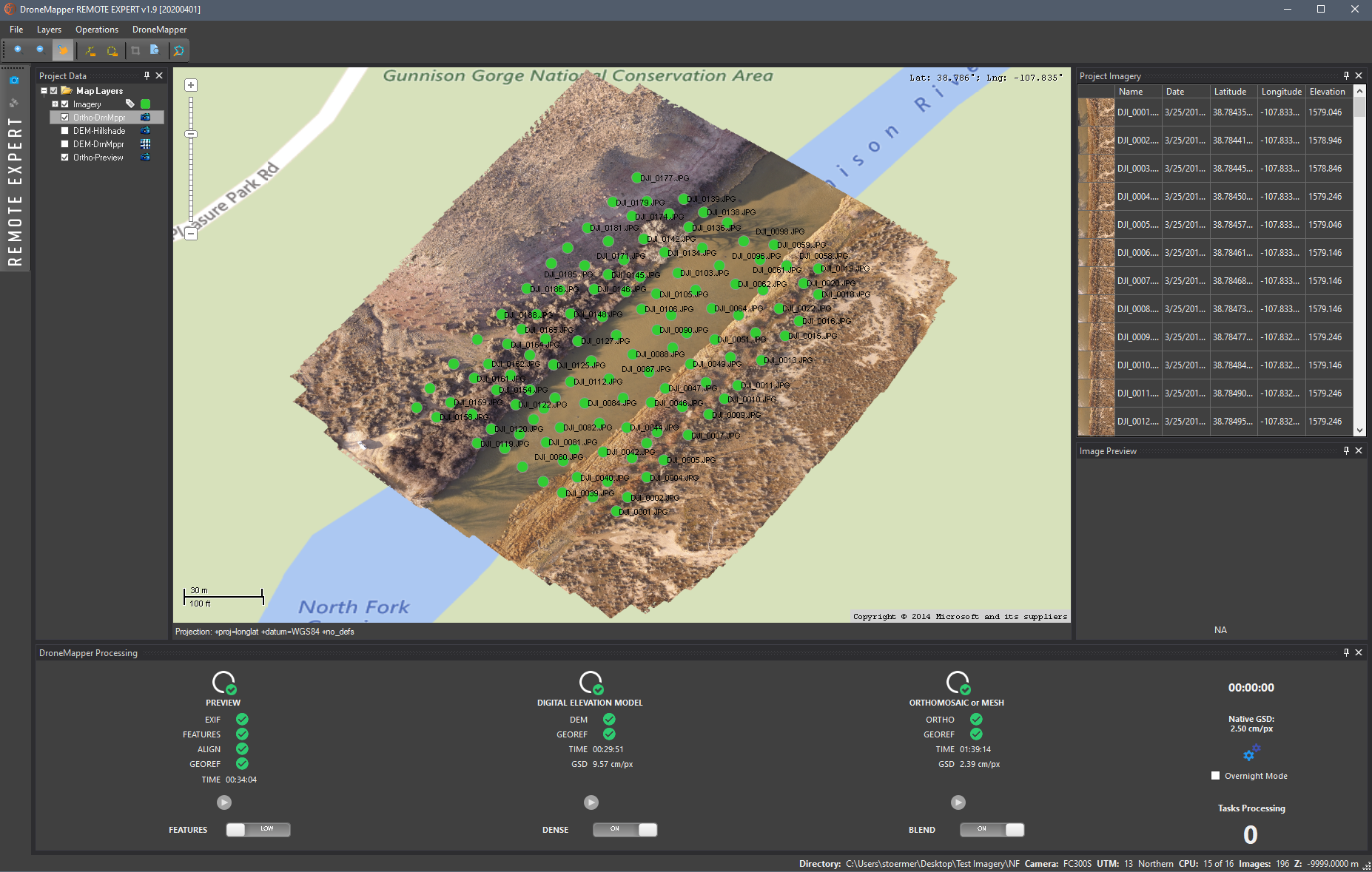
April 1st, 2020 – v1.9 20200401
- Contour shapefile is now 3D with elevation data at each vertex
- Max flow DEM algorithm now default
- Improved original DEM algorithm
- UI improvements and updates
- Dark UI theme
- New per-image pair DEM processing algorithm
- Processing optimizations
- Improved orthomosaic creation for 3D model/mesh mode
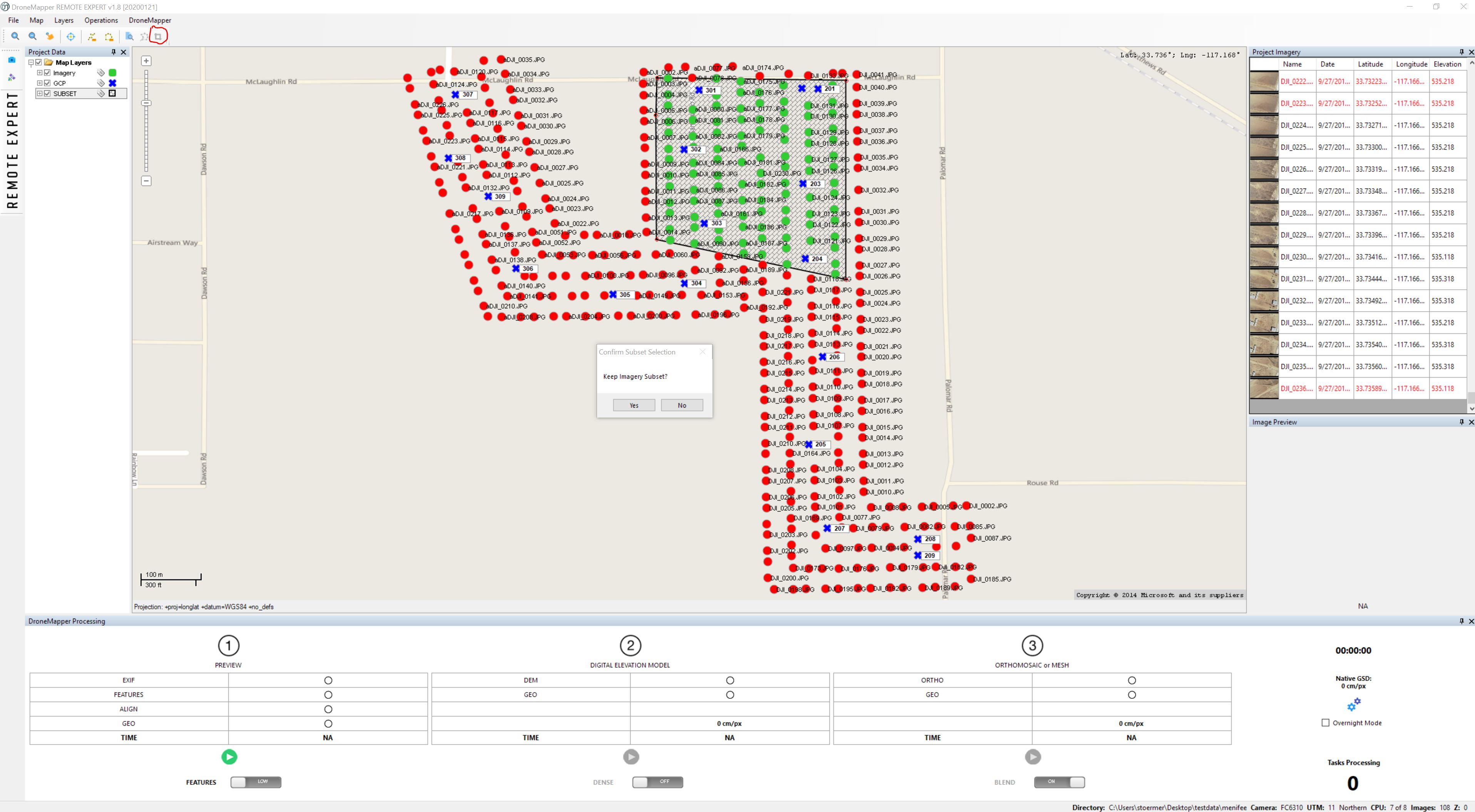
Jan 21st, 2020 – v1.8 20200121
- Add new imagery subset selection, quickly create a polygon AOI for processing or settings tests
Nov 28th, 2019 – v1.8 20191128
- Add Polish EPSG reprojection support
Oct 28th, 2019 – v1.8 20191028
- Automatically optimize DEM performance based on image count
Oct 23rd, 2019 – v1.8 20191023
- Fixed tooltip bug and license display
- Pre-generate 3 channel images (multi-threaded)
- Add “GCP Tool” to Operations menu
- New color preview orthomosaic for JPG imagery
- Reduced redundant log output
- Automatic pixel bit depth detection and processing “Settings” optimization
- Fixed 16bit ortho rendering on map view
- Remove local application settings on uninstall
Oct 16th, 2019 – v1.8 20191016
- Increased Remote Expert image limit to 10000
- Enhancements to DEM algorithms, performance and reduced memory usage (for large data sets)
- Reduction of memory by 70% for multi-threaded Orthomosaic creation and Seamline feathering
- Included license removal/cleaner
- Bug fix to scale feathered ortho to point cloud properly
- Enhancements to process MicaSense Altum Red, Green, Blue, NIR, RedEdge, Thermal stacked TIFs
- Refactored code to run original Ortho module or improved Seamline feathering module (not both as previously done/see settings)
Aug 19th, 2019 – v1.7 20190819
- Additional bba/camera calibration attempt using 10 images to create frozen camera cal
July 12th, 2019 – v1.7 20190712
- New image preview pane
- Added functionality to enable/disable images via map click for QA/QC (red = disabled, don’t use in processing)
June 30th, 2019 – v1.6 20190630
- New digital elevation model algorithm, noise reduction, smoothing option
- MaxFlow/MinCut algorithm for DEM generation settings option
June 20th, 2019 – v1.6 20190620
- Enforce “en-US” application wide culture settings
- Initialize map with WGS84 projection at application start
- Add a dependencies check, logging and alert if application problems detected
- Additional logging enhancements
June 1st, 2019 – v1.6 20190606
- Improved dji mavic air, mavic 2, mavic pro, spark processing
- Attempt generation of orthomosaic from NADIR images in a Oblique+NADIR “3D Mode” collection (requires ‘Gimbal Pitch Degree’ EXIF tags)
- New setting to override/force UTM projection zone
- Allow UTM results to be re-projected into any valid UTM or SPCS Proj4 EPSG
May 21st, 2019 – v1.6 20190521
- Remote Expert limit increased to 2000 images per mission
- Rapid license is now 159$ per year, 250 images, all features enabled
- Rapid allows free ‘Preview’ processing up to 250 images, no license required
- Updated orthomosaic post-processing with 512×512 tiled output
- UI enhancments and improvements
- Additional speed and processing improvements
- Paypal integration on license dialogs
May 7th, 2019 – v1.5 20190507
- Add SIFT tie-point generator (patent expired)
- Add functionality to detect problems in application settings and fix
- Bug fix for NADIR + oblique processing missions
May 2nd, 2019 – v1.5 20190502
- Fixed sensor management database issue
- Reduced tile size on seamline ortho feathering (better for low memory usage)
- Add additional fail safe camera calibration attempt for rolling shutter (E90, DJI Spark, etc)
April 24th, 2019 – v1.5 20190424
- Secondary refined camera calibration in 3D model if first fails
- Updated mesh normal generation
- Attempts to fix rolling shutter issues
April 17th, 2019 – v1.5 20190417
- Multi-user enabled, installs in ‘Program Files’ x64 windows
- Fix / improve short path name generation
- Secondary EXIF extraction routine if first fails
- Various bug fixes and updates
- Remove win32 OCX component in installer package
April 11th, 2019 – v1.5 20190411
- Attempt second camera calibration and bundle block adjustment with Radial model if first attempt fails (Fraser model)
- Fix an off-by-one pixel in Y on GCP marker tool
- Added a new multi-scale tie-point generation routine
- Adjusted / increased GCP report form size
- Improved error checking and progress bar
April 4th, 2019 – v1.5 20190404
- UI bug fix with processing tasks indicator
- Fixed NODATA / black pixels issue in orthomosaic
- UI improvements and enhancements
- Progressbar bug fix
March 27th, 2019 – v1.5 20190327
- PPK/RTK processing mode with embedded EXIF metadata (beta)
- New tie-point detector – multi-threaded AKAZE (beta)
- New tie-point detector – multi-threaded BRISK (beta)
- UI improvements and enhancements
- Various bug fixes
- Ability to load 3D GCP in Lat/Long WGS84 projection (use DroneMapperGCP_3D_WGS84.txt)
- Improved logging
- New optimization and tie-point filtering option
- New DEM algorithms, workflow and quality improvements
- Processing speed improvements
- Tooltips in settings form
February 26th, 2019 – v1.4 20190226
- Add initial bundle block adjustment log output
- Cleaned up log file outputs
- Add feature to alert user if sensor needs to be added to database
- Bug fix for mask tool
- Default to bing base layer if internet detected, no base layer if no internet connection
- Fixed normal generation/orientation on textured mesh
- Set MyComputer as root folder for open folder dialog
February 18th, 2019 – v1.4 20190218
- 1500 images max for Remote Expert
- Multispectral TIF processing (RGBN/RGB+nNumberOfChannels)
- TIF image support (8bit/16bit)
- Rename .DIS (disabled images on program exit)
- Additional testing and optimizations of AMD processors
- UI enhancements
November 20th, 2018 – v1.3 20181120
- New orthomosaic functionality, multi-threading (BETA)
- Orthomosaic seamline feathering (BETA)
- Alternate initial tie-point computation by image center distance to neighbors
- Added functionality to compute DEM / Ortho at native resolution
- Various bug fixes and API updates
- UI improvements and updates
- New real-time API log viewer window
- Updated/improved 3D textured mesh creation
- Improvements/simplification of mask creation tool
- Generate undistorted TIF images based on aerial triangulation results
- Process stereo pairs/epipolar imagery
- Allow RAPID users dense processing mode (4x native DEM) and 2x native ortho options
- Allow RAPID users ability to radiometric blend ortho tiles/seamlines
- Deprecated REMOTE version
- Updated processing form icons
- Fixed GSD reporting truncation issue
- Updated UI layout
- Updated UI components/icons
March 23rd, 2018 – v1.1 20180323
- Improved Oblique processing and georeferenced 3D model generation
- Implemented new high resolution georeferenced textured mesh creation
- 3D model and Oblique processing routines no longer BETA
- UI improvements
- Additional testing on older Windows versions, small bug fixes
- Code cleanup and optimizations
- Improved mask selection tool for 3D model / Oblique processing
- Remove CPU / RAM indicators on processing tab
March 5th, 2018 – v1.1 20180305
- Faster Orthomosaic blending and generation (>2x speed/performance improvements)
- Additional improvements to Orthomosaic radiometeric blending / equalization
- Refinements to DEM algorithm to improve complex terrain structure and generation
- Small UI tweaks and improvements
February 13th, 2018 – v1.0 20180213
- Fix for language/number format bug during DEM construction
January 26th, 2018 – v1.0 20180126
- Increased GCP to image distance relation to a maximum of 5000 meters
- Updated DroneMapper branding and logos
December 5th, 2017 – v1.0 20171205-930
- Volume calculations, cut/fill, surface plane, pile volume (REMOTE EXPERT only)
- Improved Digital Elevation Model (DEM) rendering with hillshade layer
- Added ability to load previously processed DEM, Orthomosaic layers for post-processing functions
- UI improvements and updates
- Raster (DEM, Orthomosaic) clipping, exporting/save (REMOTE EXPERT only)
- AOI (Area of Interest) creation for clipping, volume calculation functionality (REMOTE EXPERT only)
- Algorithm improvements and tweaks
- Elevation value of current pixel if DEM layer is loaded
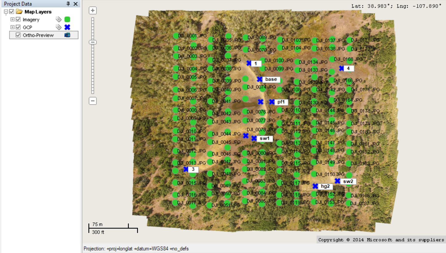
November 13th, 2017 – v1.0 20171113-910
- Contour generation and simplification (REMOTE EXPERT only)
- KMZ generation and scaling
- GCP accuracy report function, GCP visualization, Z RMSE calculations (REMOTE EXPERT only)
- UI improvements and minor bug fixes
- Updated & improved DEM processing algorithm
- Updated & improved GCP alignment algorithm
- Additional Orthomosaic blending
October 25th, 2017 – v0.9 b20171025-875 x64
- Additional error checking and recommended actions for Step 1 / Preview processing failure
- Software testing with Windows 8
- Minor UI improvements
- Generate imagery processing log file in Reports directory
- Fix for malformed lines in 3D GCP text file input, better error/format checking
October 5th, 2017 – v0.9 b20171005-870 x64
- Automatically create .KMZ super overlay of Orthomosaic. WGS84 Lat/Lon projection
- Software testing with Windows 7 Professional
October 3rd, 2017 – v0.8 b20171003-860 x64
- Allow loading of .jpeg and .JPEG files
September 26th, 2017 – v0.8 b20170926-855 x64
- Enhanced error checking and recommended actions for Step 1 / Preview processing failure
August 29th, 2017 – v0.8 b20170829-842 x64
- RAPID for DJI deprecated. RAPID now processes up to 150 images from any UAV platform or camera sensor.
- Enabled camera/sensor manager for RAPID
July 27th, 2017 – v0.8 b20170727-825 x64
- 64-bit only build, UI components
- Fatal error resolution on 64-bit only platforms
- Bug fixes
July 21st, 2017 – v0.8 b20170723-815
- BETA – Oblique imagery processing, textured mesh 3D model generation (REMOTE, EXPERT only)
- BETA – New mask creation tool for oblique / 3d model processing (REMOTE, EXPERT only)
- Creation of DrnMppr-Error.log file in application root
- Bug fix for Sensor/Camera manager
- Improved processing algorithms
- Improved alignment stage
- Application testing with Windows 10 Creators Update
- UI updates
April 13th, 2017 – v0.7 b20170413-735
- Added functionality to export .txt file(s) containing Omega, Phi, Kappa, X, Y, Z orientation (relative and world positions)
- Overnight mode, run all processing steps automatically
- Various UI tweaks and bug fixes
- Increased free DJI processing limit to a maximum of 150 images
February 12th, 2017 – v0.7 b20170212-712
- Add NDVI generation option, creates ENDVI and NDVI from NIR orthomosaic (REMOTE, EXPERT only)
- Add image EXIF pre-processor, metadata generator
- Additional, improved blending for orthomosaic (REMOTE, EXPERT only)
- Improved UI feedback from backend API, display dm3d current task count/status
- Improved logging
- Processing speed improvements
- Fixed bug with DEM scaling and certain AGL EXIF tagged data collections
February 3rd, 2017 – v0.6 b20170203-667
- Improved EXIF checks, remove ExposureTime and FocalLength requirement
- Improved alignment algorithm, image filtering and feature detection
- Add DSM/hillshade generation option, creates gray scale DSM render from DEM (EXPERT only)
- Add support for FLIR Vue Pro thermal cameras (JPGs)
- Preserve ortho preview / geo-reference results, no need to re-run once completed
- Miscellaneous bug fixes and UI improvements
- Improved logging
- Update vc_redist.x64.exe to 14.0.24215.1, installer improvements
December 25th, 2016 – v0.5 b20161225-495
- New camera/sensor manager
- Allow up to 100 images in RAPID for DJI
- UI bug fixes and improvements
- Enabled experimental multi-threaded image alignment (REMOTE, EXPERT only)
December 15th, 2016 – v0.4.6 b20161215-456
- Updated installation location
- 64-bit OS checks, application will execute only on x64
- UI nomenclature change, About dialog update
- Improved logging
- Disable power save/sleep mode during processing
- vc_redist.x64.exe added to installation bundle
December 13th, 2016 – v0.4.5 b20161213-427
- 64-bit binary optimization, AMD and Intel compatible (INTEL64 optimized, AMD slower)
- UI improvement and nomenclature change
- Fixed issue with admin user, installation user and white space
December 10th, 2016 – v0.4.5 b20161210-412
- Additional temporary file cleanup
- Fixed issues with application and non-English language
- Improved potential error messages when loading JPGs
- Small UI and menu nomenclature changes
- Fixed globalization issue, double parsing to support “,” or “.”
- 64-bit vs 32-bit pointer size fix, bitmap thumbnail creation
December 7th, 2016 – v0.4.5 b20161207-387
- Initial version of beta software release
Follow us on Twitter for the latest updates: https://twitter.com/dronemapper
https://dronemapper.com