You can find our latest example DJI aerial imagery data collections at the following URL: https://dronemapper.com/sample_data
| 4th Ave Reservoir Capacity Map – Cedaredge, Colorado DroneMapper flew 4th Ave reservoir on November 14, 2017 using their Phantom 3 Advanced drone to collect imagery for precision digital elevation model (DEM) and orthomosaic generation of the site. Approximately 80 images were collected and processed via photogrammetry to yield the DEM and orthomosaic. The original imagery and processed results are available for download. This data set was processed using REMOTE EXPERT Drone Mapping software. Click here for more details. | JPG Imagery & Processed Products [<1gb]: download | 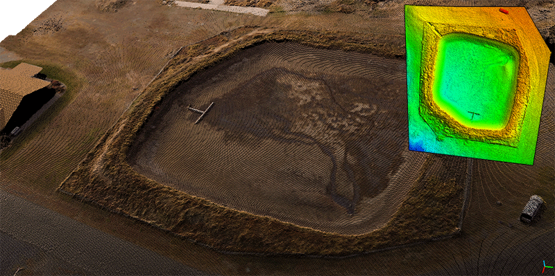 |
| Red Rocks, Colorado – Oblique An aerial survey performed with a Falcon UAV fixed-wing drone over Red Rocks, Colorado. The sensor is a Canon Powershot SX260HS with GPS enabled. This example data set contains 45 high resolution oblique images for 3D model and point cloud creation. The original imagery and processed results are available for download at dronemapper.com. NOTE: This is a 45 image oblique data set example for REMOTE, REMOTE EXPERT. Oblique imagery processing is not enabled in RAPID, this data will not process. | JPG Imagery [<1gb]: download | 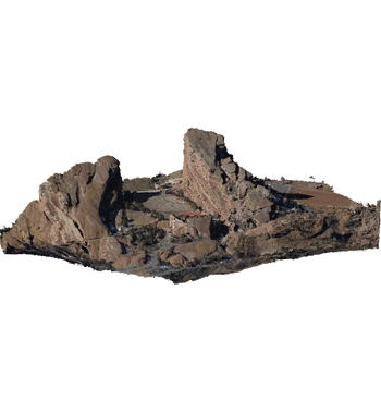 |
| Youngs Creek Reservoirs #1 & #2 – Grand Mesa, Colorado An aerial survey over Youngs Creek Reservoirs #1 & #2 on the Grand Mesa located near Cedaredge, Colorado. This collection has 58 images and was acquired with a DJI Phantom 3 Advanced using MapPilot 1.5.1 for iOS. NOTE: This is a 75 image or less data set example for RAPID. | JPG Imagery [<1gb]: download |  |
| DJI NIR – Cedaredge, Colorado A small aerial survey performed over DroneMapper HQ with a DJI Phantom 3 Advanced and Maxmax.com NIR camera system. The collection has 40 images and was acquired using DroneDeploy for Android OS. NOTE: This is a 75 image or less data set example for RAPID. | JPG Imagery [<1gb]: download |  |
| Back 9 – Cedaredge, Colorado – Golf Course An aerial survey performed with the DJI Phantom 3 Advanced over the back 9 holes at Cedaredge golf course in Colorado. Sensor is a standard DJI P3-A FC300 at 4000×3000 pixels with 664 images collected. NOTE: This is a large data set and will not load in the free version. | JPG Imagery [4gb]: download | 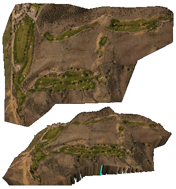 |
| Adobe Buttes – Delta, ColoradoTwo aerial survey’s performed with the DJI Phantom 3 Advanced over the Adobe Buttes near Delta, Colorado. The two flights have a large amount of overlap and the original imagery for both flights is provided for download. The imagery was collected at roughly 5cm/px GSD and covers a total area of 0.8 km sq. During this R&D mission, the DroneMapper team completed various ground control point target testing with our geoBits.iosystem. Sensor is a standard DJI P3-A FC300 at 4000×3000 pixels with 531 images collected between the two flights. NOTE: This is a large data set and will not load in the free version. | Flight 1 JPG Imagery [<1gb]: download Flight 2 JPG Imagery [2gb]: download | 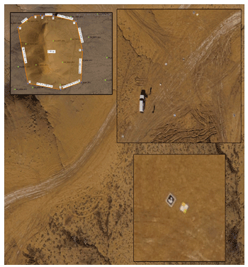 |
Let us know if you would like to feature your data set on this page!
PS. This data is free and licensed for any use, including commercial.
https://dronemapper.com