DroneMapper is very pleased to announce a collaboration with DN2K and its partners in the development of value-added products for the precision agriculture market utilizing a combination of ground-based and aerial data collections.
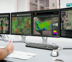
DN2K operates a unique service called MyAgCentral (shown in the illustration), a subscription-based service for growers, retailers and service providers that offers precision agricultural data and integration to key software products for managing farms. Examples of data sets include heatmaps that graphically show key farming parameters such as: crop yield, fertilizer application, ground moisture, variable rate irrigation (VRI) and Normalized Difference Vegetation Index (NDVI). DroneMapper provides support to DN2K for terrestrial data visualization and processes geo-referenced orthos in the near infrared along with corresponding NDVI maps of the crop.
Please do not hesitate to contact DN2K (dn2k.com) and/or DroneMapper (dronemapper.com) for more detailed information and how we can support your precision farming needs.