FAA 333 Exemptions – Benefits, Limitations and Suggestions
Pierre Stoermer, CEO – DroneMapper.com
We were happily surprised when we learned of the blanket exemption for a flight height of 200 feet or lower, above ground, for commercial UAS operators with the 333 granted. Now, that has sunk in and DroneMapper has had a chance to process a few imagery sets shot at 200 foot – we discuss the implications, both benefits and limitations, from an operational and imagery processing standpoint. First a couple of observations:
- Most UAS that DroneMapper is familiar with are flying compact cameras or in some cases DSLRs. At 200 foot altitude the camera/lens system produces an image on the ground with a nominal pixel size of one inch (ground sample distance/ GSD) or less at the lens’ minimum focal length setting. Without investing in an expensive camera/lens combination that could provide 2 inch GSD or utilizing a fisheye lens (which causes its own issues) you will be imaging at very high resolution.
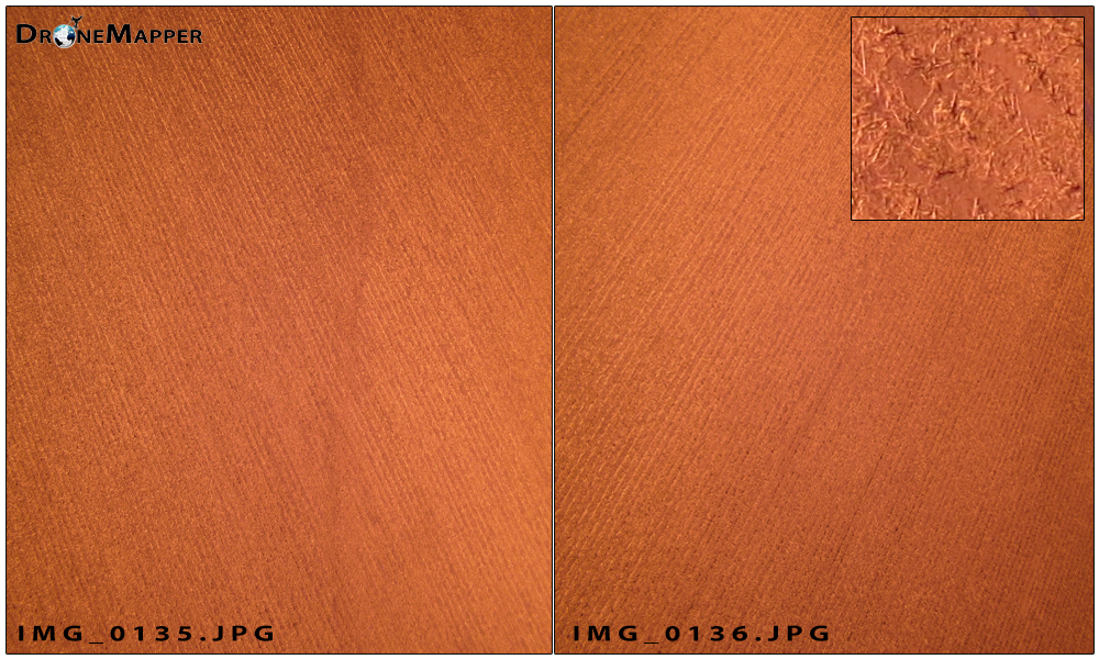
- Scenes that lack structure or features pose difficulties for image-to-image tie point generation and orthomosaicking. As the ground resolution gets finer or smaller this can be a real challenge with scenes like agricultural crop canopies, bare ground, dense forests, water, etc. where each image looks very like the previous or subsequent. Example sequential photos of a field, prior to planting, imaged at one inch GSD illustrates this point.
- Fully processed, geo-referenced ortho and DEM GeoTiffs are approximately 2-4 GB each for a 250 acre scene imaged at one inch GSD – pretty large files!
Benefits of very high resolution:
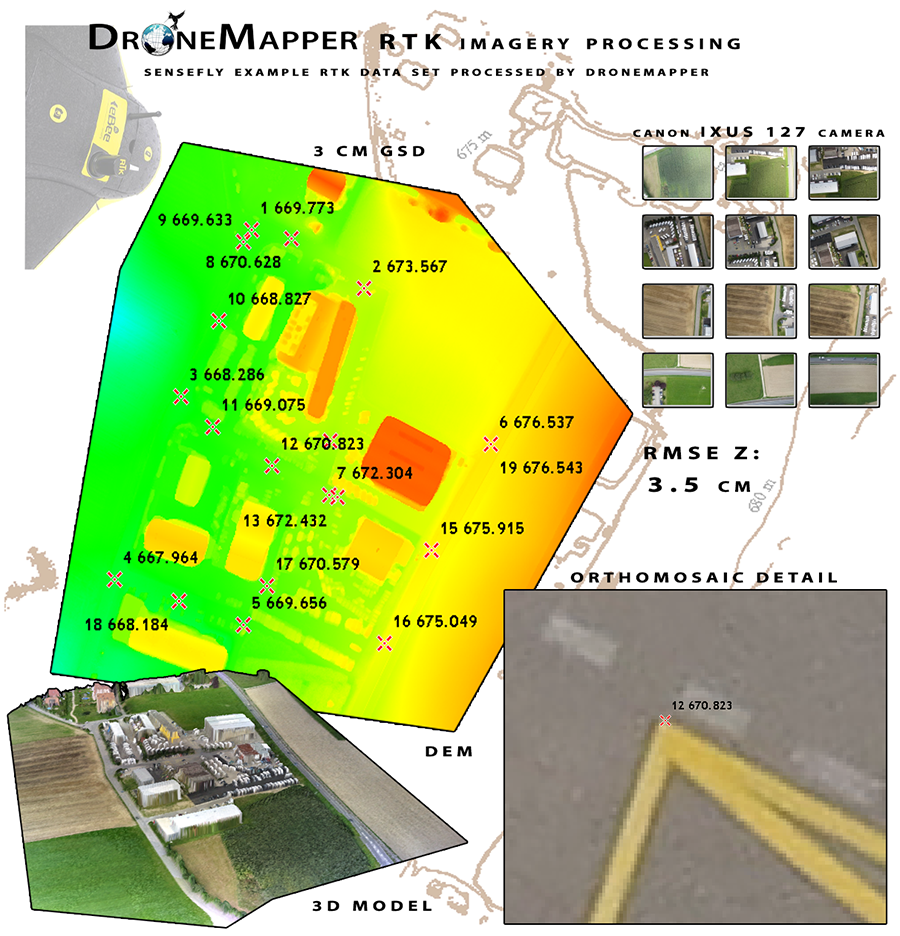
- Absolute geo-spatial accuracy of the ortho and DEM utilizing ground control or a RTK GPS solution will be one inch or less horizontal and one to three inches vertical (RMSE), essentially survey grade.
- Objects and features sized 3-4 inches can be identified by virtue of the very high resolution.
Limitations/Suggestions – Operational & Processing:
- For very homogeneous scenes, as illustrated above, consider increasing imagery collection overlaps to 75% both in- and cross-track. For a 250 acre field imaged with a 12 Mpixel camera at one inch GSD you’ll need to collect about 2,000 photos. This number can be scaled to your field size, i.e. 125 acres would require about 1,000 photos.
- Many UAS/sensor collection platforms will likely be stressed for these scenarios because of sensor triggering frequency or photo time interval, platform ground speed, platform flight endurance and GPS IMU navigational and photo geo-tagging capability.
- Processing this number of very high resolution photos for ortho and DEM construction is time consuming and will lead to significantly longer turn-around times for data products.
- The size of the ortho and DEM GeoTiffs can present problems for a number of GIS and CAD applications. Download one or more of the example data sets and verify that your application can read the GeoTiff or .ply files properly.
- For those that really don’t need very high resolution for their applications DroneMapper will be experimenting with other processing techniques to minimize turn-around time, keep it affordable and deliver the information that you need.
Congratulations to all Exemption 333 holders, the best in your business venture and please contact us if we can help in anyway. The DroneMapper team.